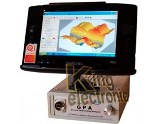
فلزیاب XL16 PRO تصویرسازی پرقدرت است که شما به کمک آن قادر به اکتشاف رگه های طلا، گنجینه ی پنهان شده و نسخه ها ی زیرزمینی خواهید بود.فلزیاب سه بعدی XL16 PRO ساخت کشور آمریکا است.
XL16 PRO METAL DETECTOR
xl16 pro metal detector USA XL16 Imager Plus With the USA XL16 Imager Plus System, you will be able to locate gold veins, lost treasure, underground ,The XL16 IMAGER works on the principle of detecting electromagnetic field You are seeing a screen shot from the new XL16 IMAGER USA.
This scan metal detector soils with Fluxgate magnetic sensors, which are controlled by microprocessor. It detects metals presented an analysis at a 3D graph. Is one of the few teams that can detect spaces empty on the ground, such as cavities, tombs, tunnels, basements, etc.
The horizontal probe has 16 controllable magnetic sensors highly developed. These high-performance sensors can measure each small change in the soil (soil anomalies).
The measurements are transmitted through the 24 pin cable of the probe to the electronic unit. During operation of the penetrating scanner of soils (GPA) takes the horizontal probe by a bar, which is connected in turn to the support of hand. The aluminium bar height is adjustable and can be divided into three parts.
The probe horizontal measures 1 meter long and has a diameter of 4 cm. With a weight of only 1500g a comfortable search is guaranteed.
Penetrating Analyzer of soils (GPA) has 3 different Software.
Software for signal processing and synchronization of magnetic sensors.
Software for the digitization of data and the transmission to the PC.
3-D KTS Software for three-dimensional representation and analysis of data.
In the event of a loss of data on the PC, customers have to submit their client and serial numbers in order to obtain our service to the client, the software by E-mail. 3-D representations and the measurement data can be transferred through the provided USB memory to another PC, for a subsequent treatment of them.
Ground Penetrating Analyzer (GPA, land penetrating Analyzer) allows a performance of up to 15 meters depth.
The recorded data are transmitted to a comprehensive mobile computer (Ultra Mobile PC) and for processing offers 3D-KTS Software (operating system), which puts at your disposal of representations both 3-D and 2-D (two-dimensional)
In the framework of the 3-D KTS Software each measurement can be represented in 3 different presentations (X, and vector). 3-D representations
They can be rotated 360 °
You can enlarge p decrease
And they can be represented in different colors
Reading of magnetic force as well as the determination of the length and width of each object, from which the measure has been is also possible. The measurement data are automatically saved to the integrated mobile computer and can be sent and transmitted through a USB memory. In this way the data can be saved and worked on another computer.
Scan of soils. Representation of the structure of the soil in the 2-D and 3-D screen as well as the storage of such data.
Scanning live. Scanning continuous representation of 2-D for greater recognition of findings or findings on the ground.
Mode magnetometer. Scanning live for the determination of the findings through the issuance of tone of the sound card of the computer and the representation of a sound on-screen diagram.


